It looks like you might have accessed this page from an outdated address. Please update bookmarks and links to:
Winter Finds Its Voice
Published: Thursday, February 1, 2024
Winter made a striking return to Oklahoma in January, surprising a state that had just experienced its fourth-warmest December on record. This frosty resurgence brought with it a myriad of wintry phenomena, including freezing fog, freezing rain, snowstorms, a blizzard warning, an ice storm warning, and the lengthiest stretch of sub-freezing temperatures since the infamous Arctic air outbreak of February 2021. Following a seasonably mild first week, Arctic air surged southward in multiple waves. The initial wave blanketed northern Oklahoma with snow on January 8-9, accompanied by a blizzard warning in the Panhandle. Snow accumulations were generally modest, though the western Panhandle saw over 6 inches, coupled with wind gusts exceeding 60 mph. This led to near-zero visibility and whiteout conditions, resulting in road closures. Subsequent blasts of frigid Arctic air infiltrated the state starting late on the 11th, persisting until the morning of the 17th, holding much of Oklahoma in a deep freeze for over 100 hours. Some northern regions endured over 100 hours below 20 degrees Fahrenheit, a clear indicator of the polar origin of the air mass. Mercury readings plummeted to as low as minus 15 degrees, marking the coldest recorded temperature in the state since February 26, 2021, when Nowata recorded minus 22 degrees. Additionally, light snowfall graced northern and eastern Oklahoma on the 15th.
After a brief respite, winter made a formidable return. Freezing rain swept across the state late on the 21st and persisted through the morning of the 22nd, prompting an ice storm warning for far eastern Oklahoma due to anticipated heavier ice accumulations and gusty winds. Up to three-tenths of an inch of ice coated the southeastern two-thirds of the state, leading to traffic disruptions and hundreds of motor vehicle accidents. Portions of Oklahoma’s turnpikes and interstate highways turned into impromptu parking lots for numerous semi-trucks. The ice was a hazard to pedestrians as well, with dozens of slip-and-fall accidents reported by state hospitals. Although temperatures finally climbed above freezing on the 22nd, inclement weather persisted through the 27th, with successive waves of chilly rain under perpetually gray skies. Fortunately, the month concluded on a brighter note, with temperatures reaching the 60s and 70s from the 28th through the 31st.
According to preliminary data from the Oklahoma Mesonet, the statewide average temperature for the month was 34 degrees, 4.3 degrees below normal and ranked as the 26th coldest January since records began in 1895. The month saw Vinita plummeting to a bone-chilling minus 15 degrees on January 16, while Waurika recorded the highest temperature of 76 degrees on the 31st. Across the Mesonet’s 120 sites, there were 171 instances of temperatures at or below zero and an additional 437 occurrences below 10 degrees. Notably, Vinita experienced the lowest wind chill value of minus 26.8 degrees on the 16th—the state’s lowest since Hooker recorded minus 33.2 degrees on December 22, 2022. Throughout January, there were 50 instances of wind chill values at or below minus 20 degrees and a staggering 759 readings at or below zero. Reflecting on the first two months of climatological winter, encompassing December and January, the statewide average temperature stood at 39.5 degrees—marginally above normal by 0.3 degrees—and ranked as the 42nd warmest such period on record.
According to data from the Oklahoma Mesonet, the statewide average precipitation for January totaled 2.2 inches, surpassing the established normal by 0.63 inches and ranking as the 22nd wettest January since records began in 1895. Continuing a familiar pattern, southeast Oklahoma received the bulk of the moisture, ranging from 4 to 6 inches, tapering off towards the northwest and the Panhandle where amounts remained generally under an inch. Leading the precipitation chart was Broken Bow with 6.27 inches, joined by 18 other sites reporting 3 inches or more. Conversely, Beaver recorded the lowest total at 0.63 inches. Nearly the entire state experienced surpluses ranging from 0.5 to 2 inches. Examining the climatological winter's initial two months, precipitation remained notably abundant, with a statewide average of 5.1 inches—exceeding the norm by 1.42 inches and ranking as the 14th wettest such period on record. West central Oklahoma marked its wettest December-January interval on record, averaging 5.12 inches, surpassing the norm by 2.97 inches and besting the previous record of 5.01 inches from 1984-85. Meanwhile, the Panhandle and north-central regions observed their third- and second-wettest periods on record, respectively. In contrast, southeast Oklahoma's average of 7.37 inches was marginally below normal by 0.12 inches.
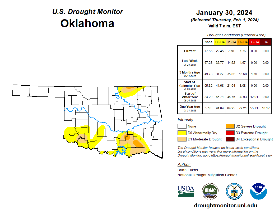
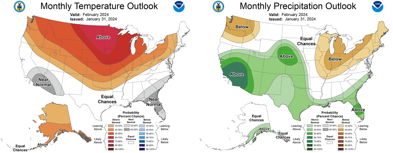
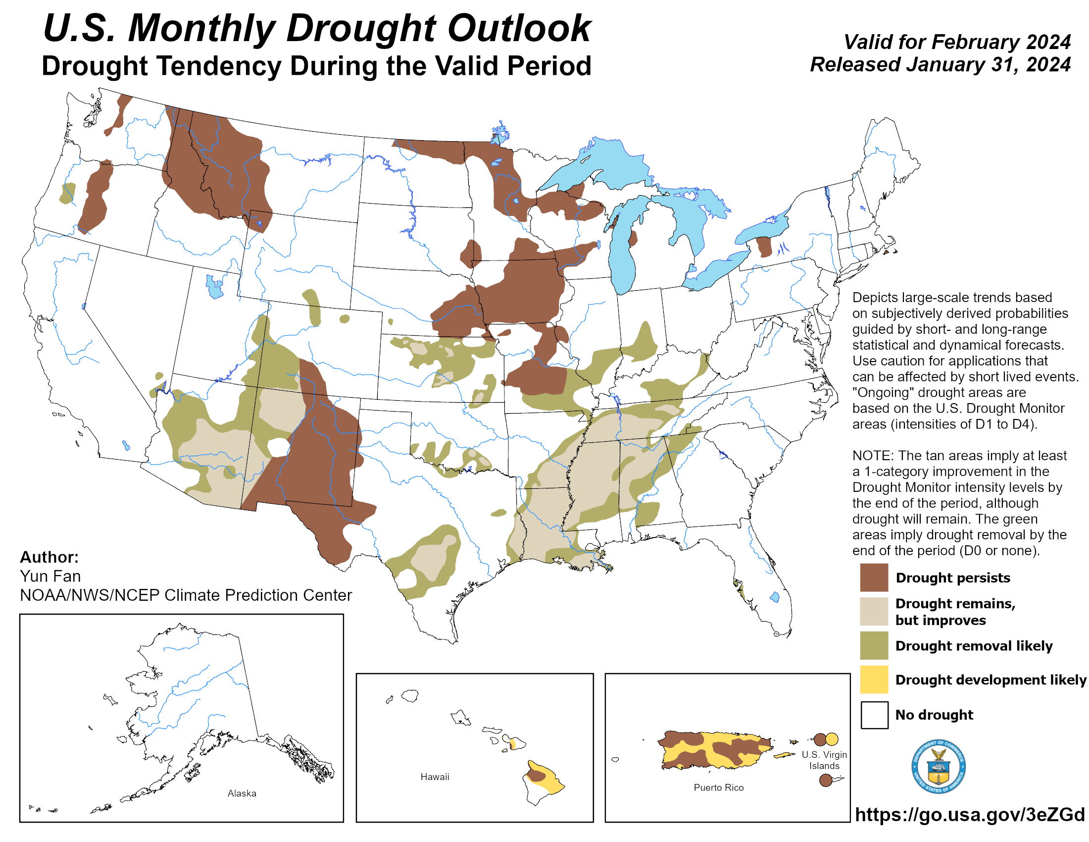
Moisture surpluses in January continued to alleviate Oklahoma's drought conditions, as indicated by the U.S. Drought Monitor's final map on January 30, which revealed that only 7% of the state remained in drought, with a mere 1.6% categorized as severe drought. The Climate Prediction Center anticipates further improvements in February. According to CPC's February outlooks, there are increased probabilities of above-normal temperatures statewide, particularly in northern Oklahoma. The precipitation outlook suggests increased chances of above-normal precipitation for nearly the entire state, except for extreme eastern Oklahoma. CPC's corresponding drought outlook for February indicates that the remaining drought areas in the state will likely be eradicated, except for localized areas in south-central and northeastern Oklahoma.